Lake Albert: Standing on Uganda's Living Border with DR Congo
A schoolboy's geography lesson comes alive on the windswept shores of Lake Albert, the Rift Valley lake that binds Uganda and DR Congo.
Founder & Chief Editor · 8 June 2026 · 4 min read
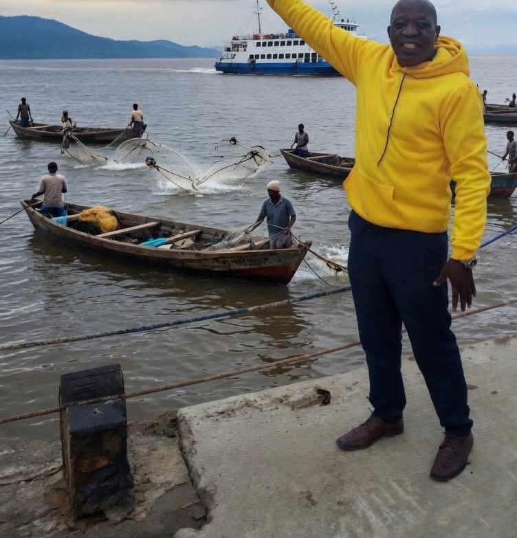
LAKE ALBERT, Uganda - The wind swept across the brownish waters as I stood on a weathered concrete jetty. Behind me rose Uganda's emerald hills. Across the restless expanse, the Democratic Republic of Congo lay beyond the horizon, wrapped in haze. One vast lake, two nations, and a living border drawn not with ink but with flowing, ever-changing water.
This is Lake Albert, known locally as Mwitanzige, the very place I once traced with a schoolboy's pencil in faded geography textbooks. Years ago it existed only as a collection of facts for my Primary Leaving Examinations (PLE) and senior secondary school studies: coordinates, measurements, bordering countries and its place within the Nile River system. Standing here, my own eyes, skin and spirit were confirming every word those pages once carried.
A classroom answer comes alive
I still remember the quiet classroom moment when our teacher asked, "What is Geography?"
My young voice answered carefully: "It is the study of the Earth's physical features, people, and how they interact with their environment."
It was a correct answer, worthy of marks, but at the time it was simply a definition to memorise. After walking through the cocoa-scented landscapes of Karugutu and exploring the steaming, emerald depths of Semliki National Park, that old classroom answer transformed from a sentence into a living experience.
Lake Albert stretches approximately 160 kilometres in length and reaches about 30 kilometres at its widest point, resting within the Western Rift Valley at roughly 619 metres above sea level. Yet standing beside it, the figures no longer feel like textbook statistics. They feel alive.
A border that breathes
This lake is not merely a geographical feature. It is an international meeting point, a natural boundary and a gateway connecting Uganda and the Democratic Republic of Congo. The border runs almost north to south through the centre of the lake, with Uganda on the eastern shores and the DRC on the western side. Here, geography is not a line drawn on a map: it is a daily reality.
Every day, goods cross these waters. Passengers move between communities. Fishermen from both countries launch their boats into the same lake, casting their nets into the same waves and sharing the same winds. They harvest from the same waters, yet return to different flags and different homes.
Textbooks explained the border. Standing on the shore, I watched it breathe.
An artery of the Nile
Lake Albert is also a vital part of the Nile River system. From the north-east, the Victoria Nile pours its waters into the lake. From the south, the Semliki River, whose journey I had followed through rainforest and hot springs, delivers water from the Rwenzori Mountains and Lake Edward. At the northern end, the Albert Nile begins its long journey towards Sudan and Egypt.
Standing there, I felt connected to a much larger story. Beneath my feet was not just a lake but a flowing artery of an entire continent.
The surface appeared calm that afternoon, yet beneath those waters lie centuries of human stories. The lake sustains fishing communities, supports biodiversity, connects nations and holds valuable natural resources, including oil reserves that have shaped Uganda's economic ambitions.
From examination questions to living memory
As I stretched my arm towards the hazy Congolese horizon, a deep sense of fulfilment washed over me. The lake I once memorised for examinations had become the lake I could touch, smell and experience. Those old questions, "Name the lake shared between Uganda and Congo" or "Which lake forms part of Uganda's border with the Democratic Republic of Congo?", were no longer just examination memories. They had become moments preserved in wind and water.
My journey through Karugutu's cocoa farms, Semliki's ancient forests and finally to the shores of Lake Albert taught me a lesson far greater than any classroom definition.
Geography is not merely written on paper. It is the wind against your face, the scent of rain carried across the water, the movement of fishermen crossing invisible boundaries, and the moment a student discovers that the places once studied from a book are real, breathing and waiting to be understood.
Lake Albert is more than a border on a map. It is a living connection between nations, people, memory and nature. It is proof that knowledge gained in classrooms can one day stand before us in its fullest form: vast, powerful and unforgettable.
And on that quiet afternoon, as the wind composed its endless song and the lake stretched before me like an open book of wonders, I realised something profound. I was no longer reading about geography. I was standing inside its living verse.
Founder & Chief Editor
Founder and Chief Editor of Osmara Digital Media. Journalist and historian telling Africa's stories through an African lens, from West Nile to the continent.
Related stories
MUSEVENI URGES EUROPEAN INVESTORS TO EXPAND PARTNERSHIPS IN UGANDA’S KEY ECONOMIC SECTORS
Government to Advance UGX 175 Billion to Complete Hoima–Busunju Road Ahead of AFCON 2027
UMSC Distributes Tablets to Muslim Leaders to Strengthen Communication